On August 5 we left Coaldale and headed for Bayfield
Colorado which is about 18 miles east of Durango. We had a climb out of
Coaldale and saw some open country and a couple if places where the road cut
through some hills.


Hit some rain and more hills but all that pales compared to three words: “Wolfs Creeks Pass”.
Those three words can make grown men cry like
little girls (that's my story and I'm stickin' to it).
Here are some excerpts from my Mountain Directory West; “7% grade-winding road next 9 miles, Trucks
stay in lower gear, must use right lane, over 55000 lbs. 25 mph, there’s a
tunnel with a 30 mph curve, after passing the second run off ramp the 7% grade
and 30 mph curves continue for another 2 miles then ease into rolling hills”. There
are also a few 180 degree hairpin curves. That is an 11 mile descent.


In the next picture you can see arrows in the road
indicating that you must merge left. Yup, a little over half way down (I’m
guessing about 5-6 miles down the slope), one of the two descending lanes was
going away. Up until this time I was going between 30 & 35 mph and keeping
things under control. There was traffic behind me as the road became a single
lane and I thought I’d step up the speed since there appeared to be no problems.
WELL, big mistake! I increased the speed to 40 -50 mph, breaking down to about
35 mph for the curves. It took a little over a mile before I started smelling
over heated. Fortunately, just after another hairpin the road had a shoulder I
could pull off on and check things out. There was no smoke, just a hint of the
brake smell. So I figured that we were getting a lot of odor coming in and that
things weren’t that bad. However, I did apply the philosophy we were taught in
the safe driving school. I stayed between 25 & 25 mph for the rest of the
descent. As far as the cars behind me, As they taught us in the class “Drive
safe, don’t worry about what the other people think, YOU WILL NEVER SEE THEM
AGAIN!”


After the rolling hills started the rest of the trip to the
campgrounds turned into a pleasant ride.The campground had a creek running through it and very
attractive flowers.


Under the heading of “Things to Do
in Durango”, taking a ride on the Durango Silverton RR is certainly at or very
near the top of the list. You can buy tickets on line or at the train station.
I recommend that going to the train station is the best way to buy tickets.
Jackie and I were both trying the internet to reserve seat and finding that
were booked. The next morning we went to the station and had no problem getting
tickets along with getting information and our questions answered. The lady
that we talked to was extremely helpful and offered good advice. We chose an
open air gondola car for a better view and better picture taking. If you decide
on a round trip on the train (the other option is the train up, bus down or
vice-versa) you need to choose which side to sit on. The train turns around in
Silverton so you see both sides of the canyon. The trip goes basically to the
north so if you sit on the left side, looking forward, you will be looking
toward the east. If you go in the morning I recommend you sit on the right
side, looking west, going and looking east on the return trip. Do the opposite
if going in the afternoon. That way you are not looking into the sun.
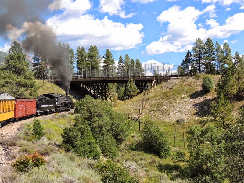
From the train station, here are
some of the sights going towards Silverton.


Part
way up e stopped in Rockport where a few more passengers boarded. There was a
pen with reindeers. Later on the train stopped to pick up backpackers.


Like so many places we have been on this trip the scenery
was spectacular.


The conductor gave us notice when we approached “the most
photographed” part of the trip.


Leaning out and looking down.

Old rail cars and a gold mine.


In Silverton we had lunch at Natalia’s,,,,,, a former
brothel. It’s not a big town so there was plenty of time to walk around. I
spotted an RV with a message. I got to talking to the owner, he told me he is
full timing. He sold his house and lives in Arizona in the winter and here in
the summer. He does some part time work in a repair shop owned by a friend.


Going to Mesa Verde was also high on our list. It is a National
Park so I could use my National Parks and Federal Recreational Lands Pass AKA a
Geezer Pass. There are various guided tours that are available.
The area was populated by people who archeologists first
called Anasazi but now are called Ancestral Pueblo People from about 550 AD to
1200AD. Then for some unknown reason the people left the area, leaving all the
structures that were their homes.
Chaplin Mesa and Wetherill Mesa are the two areas where the
ruins can be seen. Each mesa is about a six mile loop. It takes about an hour
or more, depending on how often you stop for pictures, to drive to either mesa
from the Range Station. We started at the Visitors Center and then drove to the
Chaplin Mesa.


Above pictures, you have to enlarge the picture (click on it) and even then
you can barely make out the shadow of Shiprock in the distance.
There was a fire in the area and the number of dead trees
indicates that it was quite large. Besides the cliff dwellings there were pit
houses and pueblos that were enclosed in order to preserve and study them. Here
are some of them.


The morning before we left this
area we went into Durango for breakfast. John & Marta told about a French
bakery/restaurant. Besides breakfast we brought some goodies home. Sorry the
pictures are fuzzy. We had a problem with the camera.


And now it is on to New Mexico and
Route 66.
No comments:
Post a Comment