Thursday, 21 August 2014

14. Route 66 Part 2, Acoma (Sky City) to Tucumcari NM


Route 66 Part 2, Acoma (Sky City) to Tucumcari NM
 
We left Sky City driving east on Rt.66 passed the camel and Owl Rock and around Dead Man’s Curve in the motorhome. We moved to I-40 through Albuquerque, we drove though the city in our car a  few days earlier and I didn’t want to repeat the trip in the motorhome.  


It’s not as large as Walls Drug but Clines Corners has lots of road signs. (If you have been on I-90 in South Dakota, you know what I’m referring to). They don’t want anyone to be able to say they didn’t stop because they didn’t know it was there. You can get fuel, fast food and souvenirs. Yes, we left with some magnets and a piece of Indian pottery.


In the town of Moriarty is the last remaining active Whiting Bros. Gas station, operating under the “WB” sign. In 1917, Whiting Bros. established a chain of cut rate gas stations on Rt.66 that spanned from Shamrock, Texas to just west of Barstow, California.


Many of their old buildings remain today. There are many abandoned buildings that become eye sores. What some towns are doing is painting these buildings using the original colors and painting on the name of the business.


Moriarty also has the last remaining “neon rotosphere” at the El Comedor de Anayas restaurant.


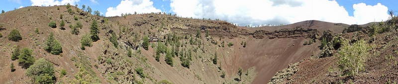
As we approached Tucumcari we saw a mesa with antennas and some strange light colored features. Using the telephoto setting I got a close up of appeared to be light colored soil or gravel. The light colored line rising from right to left is a road the goes to the top of the mesa.


I’m thinking, “ya know, I’ve heard all those stories about aliens the gov have captured and they gotta keep’m someplace”. We might have taken one or more steps beyond the boundary of the rational world, the New Mexico sum is brutal!
TUMUMCARI. Wondering about how the town got its name? Some say it comes from the 4999 foot high mountain, once used as a look out by the Comanche. The Comanche word for it was “tucumcari”. That may be true but I’m going with the Indian legend. It goes like this. Kari is the daughter of an Apache chief.  She is in love with an Apache warrior, Tocom, and he is in love with her. Now Tocom might have been a good lover but came in 2nd place in a fight for Kari’s hand (2nd place means he’s dead). Kari’s grief causes her to stab the victor and then stab herself. Her father sees all this and (you guessed it) grabs his dagger and ends his life. With his last breath he cried out “TOCOM_KARI”. Remember, this was his last breath so he didn’t have time to emphasize that it was two separate names so it was forever known as TUCUMCARI. Jeez, legends don’t get any better than that!
Tucumcari is a railroad town founded in 1901. Rt.66 came through town and business flourished due to tourist traffic. Motels, gas stations, restaurants, etc. all suffered when the tourists stayed on I-40, bypassing the town. There people who have formed or are forming preservation groups and the are some federal funds to restore some buildings and road signs.
Perhaps the best of the old motor courts is the Blue Swallow, their web site is www.blueswallowmotel.com They are listed on the National Register of Historic Places. We were told that motor court signifies a place where you get a room to sleep and there is a garage for your car. This place has some great painting on the garage walls.


The RV Park we stayed at was a former motor court. A while back some men decided to preserve it. To have a way to make a living and support the work they made it into a RV park. It is a work in progress but the people couldn’t have been more friendly and helpful Here is a picture of the original building and what it looks like today.


Tucumcari has 25 murals on the sides of buildings. The County Chamber of Commerce has a Mural Map, which is a map of the town and the mural locations plus a listing with the name of the mural.


This one is on the side of their super market.
 

The town has a museum that is loaded with memories. I worked on reducing the number of pictures Jackie & took thinking I’d put them in with the others. In the end I’m uploading them separately.


I saw a book that looked pretty ragged. Closer inspection revealed that is was how and where the pharmacist kept the records.


More museum pictures at: https://jackbarbic.shutterfly.com/10556


Monday, 18 August 2014

14. New Mexico, Route 66. Part 1, I-40, Exit 42 to Albuquerque.


We left Bayfield on August 11 drove into Durango where we turn south on Rt. 550. Ou destination was the Sky City Casino in Acoma NM. After a climb out of the Durango area the road was relatively level with some rolling hills. There was some farm lands with irrigated crops. A little further south it became high desert. As we approached the town of Shiprock we could see the rock in the distance. This is the same Shiprock that I referred to in the write up on Mesa Verde. Jackie & I experienced déjà vu moment. Both of know we have been in this area and have seen Shiprock before but we can’t remember when. Back in the 80’s we did a lot of tent camping. We camped in this area at the Grand Canyon, Brice, Zion, Monument Valley, etc. We even walked around the meteor crater in Winslow, AZ.  Seem with old age those brain cramps are coming more often.


Anyway the views were great.


There are Reservations in this area, in fact, if you go to a casino, you are on a Reservation.


There are a few pictures at: https://jackbarbic.shutterfly.com/10123

At Gallop NM we turn east on I-40 to exit 42. There we left the interstate and continued east on Rt. 66. I bought a couple of books and maps on what is referred to as the Mother Road. The continental divide and a gift shop is just east of Exit 42.


From the mountains we were now in mesa country.


Along the road are old buildings that are in pretty good shape and others that are severely deteriorated. We drove through the town of Grants. There are some old motels and signs. Some have been restored.

The “Grants Café” is one of these even though the café no longer exists.


On the eastern outskirts of Grants is a “junk yard” of old cars. Actually it’s a gold mine for the owner.


We stayed at the Sky City Casino RV Park. Here are pictures of sunrises & sunsets.


We took a trip to see the Ice Cave and Bandero Volcano. On the way there we stopped at the El Mapais Information Center. This is an area of lava flows that occurred 200 -3000 years ago. The two main things to see other than many square miles of frozen lava is the Sandstone Bluffs Overlook and the La Ventura Arch. There had been heavy rains the day before and the road leading in was under repair due to flooding and rock slides. So, we visited with the Park Ranger and took some pictures of the flowers and then it was on to the Ice Cave.


There 70 steps leading down to the cave. The Ice is colored by the minerals in the water.


Next was the volcano. The Bandera Crater is about 8300 feet high and last erupted about 10,000 years ago. I find it difficult to get good pictures of lave formations. I think it is because the lava is pretty uniform in color, masking the features. I hiked to near the top. The attendant told me that the Continental Divide is at the turn around point. Later drive on the road that bypasses the volcano we found a Continental Divide marker.


There is a store, artifacts and a rest/picnic area. I especially liked the gas pump


El Moro is a cuesta, which describes a long rock formation that gently slopes up and then drops off abruptly. Since the time of the Zunjs (about 2000 years ago) this location has been a source of water and a place to rest, as it is on an ancient trade route.


In Grants NM there is a mining Museum. This area was a source for Uranium ore in the 1950s to early 1960s. The first floor of the museum houses mineral and pottery displays and a theater showing films on mining. Below this floor is a replica of a mine. A volunteer named Jack Farley gave us a tour and shard stories of his experience mining in this area. He told us that he started as a kid doing the menial tasks and worked his way up to being superintendent of three mines. He said mining was his passion and that he loved being underground.


We took a day to explore Rt. 66 going east to Albuquerque. Along the way we passed great scenery, a rock that looked like a camel, Owl Rock and followed the road around Dead Mans Curve.


There was a stretch of road warned of potholes, bumps, etc. We drove it in the car, it would shake the fillings out of your teeth. We saw a couple of Rangers patrolling the area and came upon a ranch entrance.


In Albuquerque we saw old stores and abandon motels.


Then there is Budville. Here’s the short story, (taken in part, from an Exploring Route 66 Visitor Guide). Bud (Howard Neal Rice) and wife Flossie run a wrecker service, garage, trading post & gas station. In 1967 Bud is murdered in a hold up, no one knows who did it. In 1997 Flossie sells the wrecker and closes the garage. Gus Rainey, retired Texas lawman and a close friend of Bub's suspects Flossie’s new (ex con) husband. Gus shoots Flossie’s second husband dead. Gus was never tried for the killing…………….New Mexico law in action.