Wednesday, 16 October 2013

Tomoka State Park


Tomoka State Park, near Ormond Beach Fl                        10/6/13 to 10/12/13

We finally got some free time, five days, Monday through Friday with no doctor appointments or other issues to keep us at home. So, I made reservations at Tomoka State Park which is a short distance away in miles (about 66 miles) but is a world away with respect to our daily lives.


The sites are range from small tent sites to sites capable of handling larger motorhomes. Since ours is 32 feet we found several sites that would work.
  

There is archaeological evidence that the Timucua people were here as far back has 1100 to 1300AD, predating the European founding of St. Augustine. So they were probably waiting to be “discovered” by Ponce de Leon in 1513. The people in this area had a chief named Tomokie and the park has a statue at the north end.


There is a camp store where besides supplies you can rent canoes. There are docks and vwery comfortable veranda where Jackie & I spent time relaxing, looking at the salt marsh, Tomoka river and reading from our Kindles.


Taking a ride north of the park we came across the remains of a sugar mill.


One day we took a ride along AIA to look at Anastasia State Park for a possible place to go camping. Along the way we found a campground on the beach in Flagler Beach. We stopped and walked around. Looks like we will be doing some camping here.  We need to check the calendar for next week with no appointments.


There was a turtle nest on the beach. It was marked with stakes and orange tape.


One item of interest at Anastasia State Park was the trees. Here are a couple of pictures that show how they bend away from the water. The two explanations I know are that they bend away from the salt spray or it wind cause them to bend.

CR 4011 leads to the park from Ormond Beach. We found many scenic roads, mainly due to how the branches of the Live Oaks, that lined the road, grew to over the road and in some places formed a canopy. Some of the limbs are the base for other plants like ferns and of course no self-respecting live oak would ever be caught with some Spanish Moss clinging to it.


Another place we visited was the Bulow Plantation Ruins.  Land for the 4675 acre plantation known as Bulowville was purchased in 18521 by Charles Wilhelm Bulow. When he died two years later, his son John inherited the plantation and built a sugar mill. Between 1823 and 1836 Bulowville was the largest sugar plantation in East Florida. In 1835 and against Bulow’s objection the plantation was occupied by the military. Major Benjamin Putnam and a company of men coverted Bulowville into a military fortress.  Refugees from the Seminole War came there. It is believed that the plantation  was burned down by the Indians after Bulowville was abandoned by the soldiers on January 23, 1836.
The sugar mill then………..
  

And now………………………………….


Today there is very little left of the plantation home.


There is canoe rentals and access to Bulow Creek.


Here are some photos of a pond near the house, a visitor building and some trees that looked interesting.


There was a small garden with examples of the crops that were grown on the plantation.


As usual the time slips by too fast and tomorrow we will be heading home. However, today was another fun day. We met with a couple from motorhome club, the National Untied Travelers, more commonly known as “The NUTS”.  Did some sight-seeing, had lunch at a restaurant on the water and a great time. We will be together in the near future at our first rally of this season starting November 7.

There are more pictures on my shared site at: https://jackbarbic.shutterfly.com/6402


Tuesday, 13 September 2011

Still On The Road


Although the caravan ended August 6, we are still on the road. After leaving Maine we visited friends in Vermont. We then made a couple of stops in New York state and spent two weeks in a campground near Ashtabula OH.  We visited Jackie’s cousin, my sister and their husbands.  When our stay was up at the campground we drove to my sister’s house in South Euclid OH where we left the motor home in their driveway and the four of us took the car to Sun Prairie WI, the town where my brother, his kids and grandkids live.

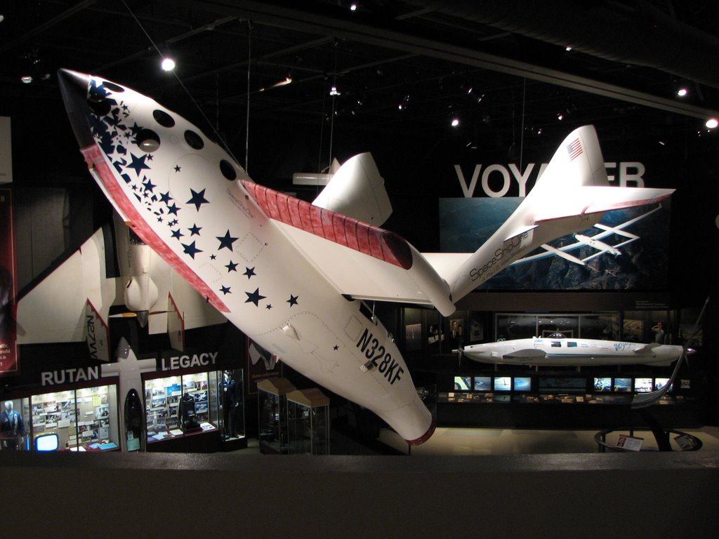
While there we went to Oshkosh to the Experimental Aircraft Association museum. What a wonderful collection of aircraft. More pictures are at: http://summer2011jb.shutterfly.com/pictures/3428

                 4356 4382 


                4358 4364


On the way back we stopped in Auburn IN. If you like automobiles, the Auburn, Cord, Duesenberg Museum is a stop you will enjoy. It’s kind of like walking around car heaven.
The museum is housed in the only remaining original factory building.   
           4613 4453.3


The cars are well maintained, a reflection like this can’t be seen in a car with a dull finish.

      4467.1 4467.4


Tonight we are in a campground near Ashland KY where we have been visiting some of Jackie’s relative for the past several days. Tomorrow we head to the Roanoke VA area for a few days, then we will visit our niece in the Florida panhandle. After that I guess we have to head home, should arrive there Sept. 29.  We started this trip on May 30, it will be a little sad to be off RV Time and back to the real world. 

Wednesday, 17 August 2011

The end of the caravan

Aug. 2, 2011
So, the race begins to end the caravan on time. Today was a 235 mile drive (point 1 to 2 on the map) from Louisbourg, NS to Truro, NS. We were here earlier in the trip but it was just a stop for the night place this time.  We did have an ice cream social the evening. Ice cream always makes everything better.
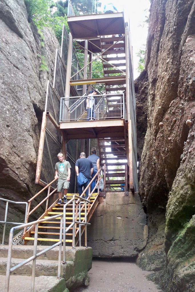
 Aug. 3, 2011.  The next morning our friends Herb & Ann joined us in leaving the campground at 6:00AM for a 125 mile drive to Hopewell Cape, NB (point 2 to 3 on the map). The reason for our early departure was the desire to get to Hopewell Rocks during low tide so that we could walk on the bottom of Chignecto Bay which is the most northern reaches of the Bay of Fundy. Here is where the “Flower Pots” are. The Flower Pots are sea stacks eroded at the base, with trees and plants growing on top. If you want read more about them go to: http://bayoffundy.com/articles/flower-pot-rocks/  We went to the park with our motor home and car, Herb pulled in with his truck & fifth wheel. Fortunately they have provided lots of parking for RV’ers and busses. It is a long walk downhill to the point where some 100 steps start down to the bottom. There are gas powered carts that you can ride for $2.00 per person. I would have gladly paid more for the ride back up the hill. Later that day when we came back to see high tide, we rode the cart both ways. Here are some pictures that show the how things change between low & high tide.
               4172.1  4172.


 For this set we couldn’t stand in the low tide location
                       
          4241.1 4241.2


In the first picture, you can see a rock with a hole in it that people can walk through. Here is a picture of Jackie standing in the opening. She’s the one in the maroon jacket and white slacks. It gives you an idea about how high that tide is.
4178
Jackie with Ann & Herb and a rock named ET.
                         4177 4216


There was a park ranger that was stacking rocks on one another. He was talking about how every rock has a balance point. He said that he stacks the rocks just for fun and to give the visitors something to try.
            4206 4207


 At the top of the stairway there is a clock and a posted time to return to the stairs so you don’t get caught by the rising tide. The return time of 1:05 was posted in the morning during low tide. I took this picture when we returned in the afternoon. They apparently do not change the time during high tide. Makes sense since you would be underwater at the bottom of the stairs. There is also information about what to do if you do get caught.
         4257 4258


4195P
More pictures of the rocks at Hopewell Cape are at: http://summer2011jb.shutterfly.com/pictures/3354


Aug. 4, 2011. Most of the caravan took their time leaving, those that missed low tide the day before went back to catch it before starting the 107 mile drive to St. John, NB (point 3 to 4 on the map) . 

Aug. 5, 2011. The next day we took a bus tour of St. John The first stop was at the Reversing Falls. These are rapids in a narrow gorge on the St. John River.  At low tide the water rushes downstream into the Bay of Fundy, however, at high tide the water from the bay pushes upstream causing the rapids to reverse the flow direction. The water velocity is constantly changing going from its maximum velocity to zero at tide reversal. There is about a 20 minute period when the water is still.
4267
This facility is a pulp mill owned by the Irving company. All through our trip we saw and patronized Irving gas stations. Our tour guide told us a little about the company. It is a privately owned company run by the two sons of the founder. They have many different business interests. Coming back through Maine, Vermont and New York I saw a few Irving stations so they have business interest in Canada as well as the US
4272
There are jet boat ride available. We were told that there are strict regulations for boat traffic
crossing this area. I don’t know how they apply to the people who run the jet boat rides. Downstream there is a bridge and just the other side is a restaurant that we had a group dinner at that night.
 
             4278 4276


Another stop we made was at the Carleton Martello tower. The plaque tells the important parts of its history. There was a diagram of the tower and surrounding fortifications showing how the harbor was to be protected.  It has been restored and you can go into the tower to see where the troops lived.
             4286 4287


                     4293 4289


                   4290 4291


4297
Later that day we had our “Farewell Dinner”. This wasn’t the entire group since some folks left the caravan before this. Actually it was the first farewell dinner because most of this group returned to the Pumpkin Patch RV Resort and we did it again. Anything for a “LEO”, which means “Lets Eat Out”
4301
When we arrived the incoming water was flowing rapidly under the bridge. There was a rock that we could see later that gives you an idea of how fast the water was flowing when we arrived and later what it was like just as the tide was starting to reverse.
        4303  4315


There were two boats that went upstream during slack time. A little while later you could see the start of the water starting to flow downstream (the curved line in the river) past where I was taking pictures from.
       4307 4313


After dinner we drove to the place where we took picture earlier that day.

Aug 6, 2011. We packed up and drove the 179 miles (point 4 to 5 on the map) to the Pumpkin Patch RV Park. At the US border there was a separate line for RV’s. It was mostly made up of folks in our caravan. When it was our turn they came on board and took some nectarines and a lemon. Although the caravan was officially over there were several of us including the wagon master and tailgunner that spent a couple of days there before heading our separate ways. It was the last hurrah, we had come full circle.

0205